Curiosity’s Martian dawn panorama frames a puzzling layer
Six Mastcam frames, left without white balancing, show morning light on wind-sculpted ridges that may hide a missing chapter of Mars’ climate history.
 By
Desmond Hallam
By
Desmond Hallam
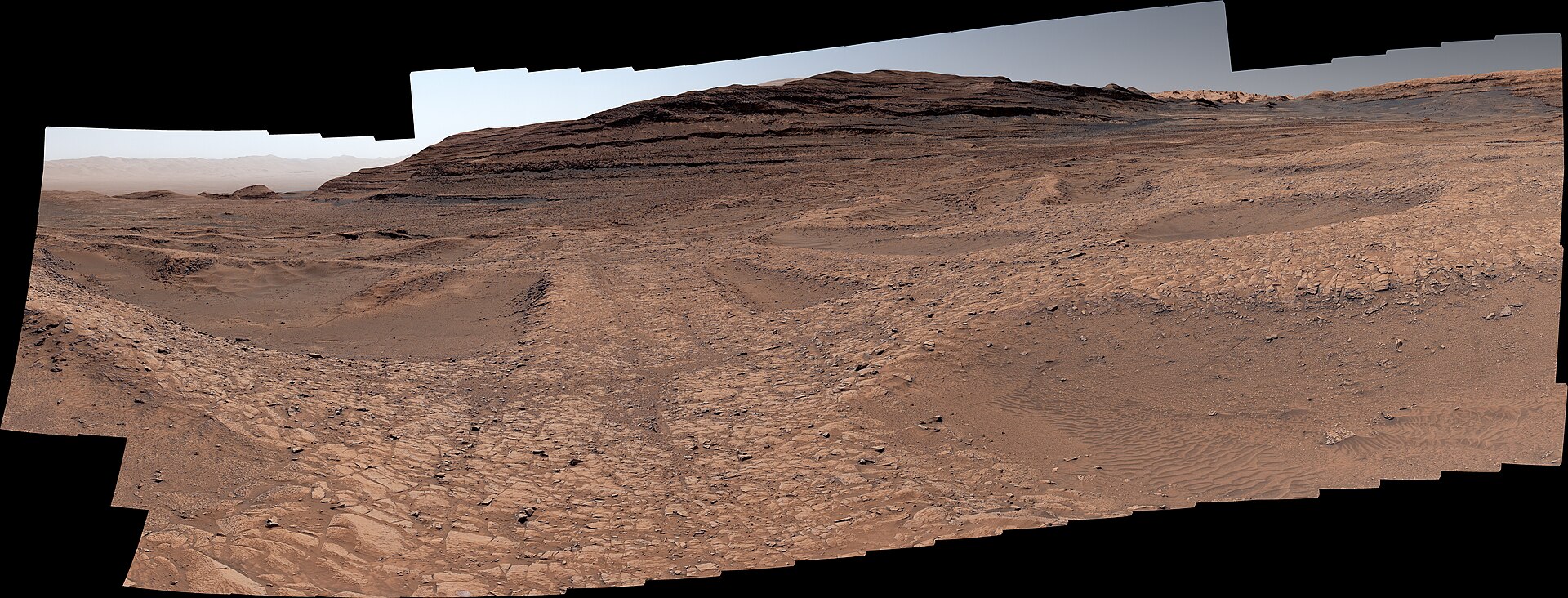
NASA’s Curiosity rover has photographed sunrise breaking over yardangs, streamlined ridges carved by wind into compacted sediment, on the northwestern flank of Mount Sharp. The image offers the most detailed look yet at a rock layer that sits awkwardly on top of the mountain and that mission scientists cannot yet explain.
In brief
- Curiosity photographed sunrise over distant yardangs on Aug. 11, 2026, sol 4,982 of its mission.
- The yardang layer stretches about 16 km across the northwestern flank of Mount Sharp.
- Scientists are unsure how the layer formed; volcanic ash is one hypothesis.
- The team hopes to reach the base of the yardangs in 2027 and study it with the robotic arm.
A morning scene in Gale Crater
The rover recorded the view on Aug. 11, 2026, its 4,982nd Martian day, or sol. Local time inside Gale Crater was about 8:30 a.m. In the foreground the terrain carries a bluish tint, while the distant crags catch the early light along the horizon.
What looks like a single wide frame is in fact six separate shots from Mastcam, the rover’s mast-mounted camera. They were assembled into one panorama only after the data reached Earth. The processing team also departed from routine: most Mastcam pictures are white balanced to approximate how colors would appear under familiar lighting, but this one was left uncorrected. NASA describes that decision as an artistic one, intended to keep the look of a Martian morning intact.
Where the yardangs sit on Mount Sharp
Yardangs form when wind scours cohesive sediment into sharp, aligned ridges. On Mount Sharp they make up their own layer, and its dimensions are considerable.
The mountain works like a geological archive. Each of its stacked layers preserves a distinct stretch of Martian history, and reading them has shown Curiosity’s team that lakes and streams once covered this part of the planet billions of years ago. That water eventually vanished, leaving salty minerals behind in the rock.
A layer that does not fit the sequence
Where the rover is climbing, the sequence of layers is capped by the yardang deposit. According to NASA, the mountain may already have started eroding before that cap was laid down, which would leave a gap in the otherwise continuous climate record Curiosity has been reading on its way up.

Ashwin Vasavada, Curiosity project scientist at NASA’s Jet Propulsion Laboratory, has described the deposit as an outsider. “The yardang layer looks out of place. It’s the wrong color, the layers tilt at an odd angle, and it almost appears plastered on,” he said, as reported by Phys.org. He has also said the layer was added later, above an unconformity, the term geologists use for a break in time when older layers wore away before fresh material accumulated on top.
Its origin remains open. One hypothesis treats it as a pile of volcanic ash, comparable to deposits seen along Mars’ equator, though that idea is unconfirmed.
“But that’s what makes it exciting to reach. No one is sure exactly what created this layer, but one idea is it may be ash deposited by ancient volcanic eruptions.”
Ashwin Vasavada, Curiosity project scientist, NASA’s Jet Propulsion Laboratory
The ridges themselves may be a later chapter. Once new material stopped accumulating on the mountain, wind could have removed part of it and sculpted what remained into yardangs, a possibility rather than a settled finding.
How the mission gets closer
Curiosity is now in the second year of its fifth extended mission, which opened with a survey of boxwork ridges. For much of the coming year it is expected to cross layers rich in sulfates and carbonates, minerals that point to the surface drying out long ago. As reported by Starlust, the team expects the rover to reach the foot of the yardangs in 2027, where its robotic arm and instruments could examine the formations directly. One account quotes a window of 2027 or 2028.
- Curiosity launches.
- The rover arrives at Mars.
- The ascent of Mount Sharp begins.
- Curiosity reaches 1 km (0.6 miles) above the Gale Crater floor, the greatest elevation any rover has gained on Mars.
- The dawn panorama of the yardangs is captured.
- Target date to reach the base of the yardang layer.
The rover itself was built by NASA’s Jet Propulsion Laboratory, which Caltech manages in Pasadena, California. Mastcam, the camera behind this panorama, was built and is operated by Malin Space Science Systems in San Diego.
Featured image. Source: Wikimedia Commons. Credit: NASA/JPL-Caltech/MSSS. License: Public domain.